| Common links by type of Award | ||||||
|---|---|---|---|---|---|---|
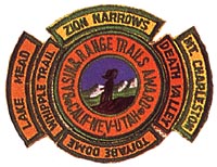
| HOME | Alphabetical | By Council | By Category | By Area | Misc. Links | Gen Requirements |
Any of the following Death Valley trails may be taken to qualify for the DEATH VALLEY SEGMENT.
DEATH VALLEY
SCHWAUB PEAK HIKE
Requirements:
1. LENGTH: 20 miles from Inyo Mine to the peak and back to the
highway via Red Amphitheater and Hole-in-the-Wall. Add 10.5 miles
if you hike from the highway to Inyo Mine. Subtract 8.5 miles if
you arrange to be picked up at the jeep trail in Red Amphitheater.
2. LOCATION: Schwaub Peak is the second highest peak (6,448') in the Funeral
Mountains of the Amargosa Range, Death Valley National Monument,
and is about 95 miles northwest of Las Vegas, Nevada
3. DIFFICULTY: Moderately difficult.
4. DESCRIPTION: A cross-country hike (no trail) from the end of the jeep road
above Inyo Mine to the peak and back down to Red Amphitheater. It is a 2 mile
hike to the wash that drains the north side of the peak. If you arc backpacking,
leave your pack here, hike to the peak and pick up your pack on the return.
Follow the drainage down to the jeep trail in Red Amphitheater, then follow this
jeep trail through Hole-in-the-Wall down to highway 190. It is a 2,400' climb
from the end of the jeep road in Echo canyon to the peak and a 5,400' decent
from the peak to the highwav.
Much of the hiking is on loose gravel on jeep trails and washes.
5. CAMPING AND WATER: Plan on a dry camp. No water is available anywhere
on this hike. Plenty of camping spots, but all are rocky.
This hike should only be taken in cool weather.
6. MAPS: Ryan, Calif. (USGS 15 min.), Furnace Creek, Calif. (USGS 15 min.)
TITANOTHERE CANYON TRAIL
Requirements:
1. LENGTH: 12 miles one way.
2. LOCATION: Grapevine Mountains of the Amargosa Range, Death Valley
National Monument, 120 miles northwest of Las Vegas, Nevada
3. DIFFICULTY: Easy
4. DESCRIPTION: All down hill, no foot path. A typical Death Valley
canyon with the route usually following a rocky wash bottom. Canyon
walls are steep and narrow just above Lostman Spring, but not as narrow as Titus Canyon.
The last 4 miles is across a broad alluvial fan.
5. CAMPING AND WATER: No water available.
Camping sites are not good - the ground is rough and rocky.
6. MAPS: Bullfrog, Grapevine Peak, Stovepipe Wells (USGS 15 min.)
COTTONWOOD CANYON TRAIL
Requirements:
1. LENGTH: 26 miles round trip.
2. LOCATION: Cottonwood Mountains of the Panamint Range, Death Valley
National Monument.
3. DIFFICULTY: Easy.
4. DESCRIPTION: About 2,800' on steady mild grade over 13 miles from
the mouth of the canyon to the springs. A typical wash bottom hike - mostly in loose gravel.
Parts of the canyon are deep, narrow, and twisting.
5. CAMPING AND WATER: Plenty of fuel and water and good camping
sites at the Cottonwood Springs.
6. MAPS: Marble Canyon, Stovepipe Wells (USGS 15 min.).