Requirements:
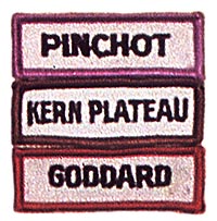
1. This is an indicator patch to show where a High Adventure Backpack Award was earned and so may be earned in conjunction with any High Sierra Backback Award.
2. The Trek must be a genuine backpack of 30 hours scheduled backpack time in at least 6 consecutive days and 5 nights on the trail.
3. Only I Indicator Segment may be earned on each Trek. At least 16 hours of scheduled backpack time must be in the Sector designated by the Segment.
4. Comply with the General Requirements of San Diego Trek Aid #105.
5. The designated areas of the segments are:
 YOSEMITE - Yosemite National Park
 TRANS-SIERRA - Any Trek that crosses the High Sierra Nevada north of
an East-West line through Kemville and South of an East-West line through
the northern boundary of the Emigrant Wilderness.
TRANS-SIERRA - Any Trek that crosses the High Sierra Nevada north of
an East-West line through Kemville and South of an East-West line through
the northern boundary of the Emigrant Wilderness.The following Indicator areas are designated by the US Geological Survey 15 minute quadrangle topographical maps.
 BANNER/RITTER - Mono Craters, Merced Peak, Devil's Postpile, Mt.
Morrison and Mt. Abbot.
 SEVEN GABLES - Mt. Abbot, Mt. Tom, Blackcap Mountain and Mt.
Goddard.
 GODDARD - Mt. Goddard, Big Pine and Blackcap Mountain.
PINCHOT - Mt. Goddard, Big Pine, Marion Peak and Mt. Pinchot.
DIAMOND MESA - Mt. Pinchot, Mt. Whitney, Olancha and Kem Peak.
 GREAT WESTERN DIVIDE - Mt. Whitney, Triple Divide Peak, Mineral
King and Kem Peak.
GREAT WESTERN DIVIDE - Mt. Whitney, Triple Divide Peak, Mineral
King and Kem Peak.KERN PLATEAU - Hockett Peak, Monarch Mt., California Hot Springs, Kemville and Lamonte Peak.
 WESTERN LAKES - Shuteye Peak, Kaiser Peak, Shaver Lake, Huntington
Lake, Blackcap Mountain (only that part outside King's Canyon National
Park), Tehipite Dome, Patterson Mountain, Giant Forest, Kaweah, Mineral
King, Camp Nelson, and California Hot Springs.
  NOTE: Multiple Indicator Segments may be earned for extended treks.
Prior written approval of the High Adventure Team is required.