| Common links by type of Award | ||||||
|---|---|---|---|---|---|---|
| HOME | Alphabetical | By Council | By Category | By Area | Misc. Links | Gen Requirements |
Sedona Rim country is a unique and beautiftil area vith many rugged canyons, forested slopes and isolated plateaus and mesas. Most hikes in these areas are best as day hikes and lend themselves to small groups (groups of 10 or less). Several hikes can be overnight trips.
OAK CREEK - SEDONA RIM HIKES
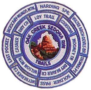
WILSON MOUNTAIN, EAST POCKET TRAIL, WET BEAVER CREEK, DRY BEAVER CREEK, LOY TRAIL, MOONEY TRAIL, HARDINGS SPRINGS TRAIL, COOKSTOVE TRAIL, THOMAS POINT TRAIL, CASNER CANYON TRAIL, JACKS CANYON-MUNDS MOUNTAIN, SOLDIER PASS TRAIL, VULTEE ARCH-DEVILS BRIDGE, DRY CREEK TRAIL OAK CREEK - SEDONA RIM HIKES
Requirements:
1. Contact the Council for updated pamphlet containing trail descriptions, notes, maps and other useful information.
2. The OAK CREEK - SEDONA RIM center patch is earned only after completing one overnight hike and the day hikes utilizing "no trace" camping.
NOTE: Only two hikes have dependable water and the others will require a "dry camp".
OVERNIGHT HIKES:
1. Wilson Mountain 6 - 8 miles
2. East Pocket Trail 5 - 7 miles
3. Wet Beaver Creek 6 - 8 miles
4. Dry Beaver Creek 6 - 8 miles
5. Loy Trail 10 miles
6. Mooney Trail 12 - 14 miles
DAY HIKES:
7. Harding Springs Trail 1.5 miles
8. Cookstove Trail 1.5 miles
9. Thomas Point Trail 2 miles
10. Casner Canyon Trail 4 miles
1 1. Jacks Canyon -Munds Mt. 9 - 10 miles
12. Soldier Pass Trail 4 miles
13. Vultee Arch-Devils Bridge 5 - 6 miles
14. Dry Creek Trail 6 miles