Coastal Processes
& Coastal Erosion Pre-lab
Use
the information below to answer the pre-lab questions.
The information below is adopted from: Turbeville,
J., Meldahl, K., and Metzler, C., 2008. Field Trip #2: Coastal Geology and
Erosion Hazards in Northern San Diego County. In:
Trujillo, A.P., editor, 2008, Geoscience Investigations in Northern San Diego
County and Beyond: Student-Directed Explorations. Field Trip Guidebook: National Association of
Geoscience Teachers Far Western Section Conference. March 14-16, 2008, Palomar
College.
The
Oceanside Beach Compartment
The beaches of northern San Diego
County are part of the Oceanside Beach
Compartment: the 50-mile-stretch of beaches that extends from Dana Point in
Orange County south to La Jolla (figures 1 and 2). The components of the Oceanside Beach
Compartment are:
·
Rivers, gullies, and eroding coastal bluffs that deliver sand to the
beaches.
·
Net southward longshore drift due to prevailing swell from the northwest.
·
La Jolla Canyon, a submarine canyon that funnels
southward-drifting sand away.
Net longshore drift in the
Oceanside Beach Compartment averages ~275,000
cubic yards of sand per year to the south, although there is great year-to-year
variability (SANDAG 2007).
In addition to its net
southward movement via longshore drift, beach sand also moves onshore and
offshore seasonally. Small waves (most
common in summer) cause net shoreward movement of sand, whereas large waves
(most common in winter) cause net seaward movement. The result is a seasonal shift from a wide,
sandy summer beach to a narrow,
rocky winter beach.
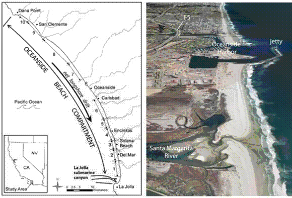
Figure 1. The Oceanside Beach Compartment extends for 50
miles from Dana Point to La Jolla.
Rivers and coastal bluffs supply sand to the beaches. Net southerly longshore drift carries an
average of ~275,000 cubic yards of sand south per year. The sand eventually leaves the beach
compartment when it flows down La Jolla Canyon, or when it is carried offshore
during storms. Obstructions such as the
jetty at Oceanside Harbor interrupt the southerly movement of sand. The photograph looks south along the coast
toward Oceanside harbor. Notice that the
beach north of the jetty is wider than to the south. (Figure reproduced by
permission of Dr. Scott Ashford; photograph courtesy of Google Earth.)
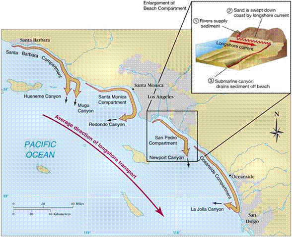
Figure 2. The Oceanside Beach Compartment is one of several
beach compartments along the coast of southern California. Each compartment
consists of several rivers that deliver sand to the beach, net southerly
longshore transport of sand along the beach, and a submarine canyon at the
south end of each compartment that removes sand from the beach. (From Essentials of Oceanography by Trujillo
and Thurman.)
Origin of Beach Sand
Until recently, most geologists
assumed that rivers supplied 90 percent or more of San Diego County’s beach
sand. But in 2005, findings announced by
two independent research groups at the University of California San Diego (UCSD) converged on an unexpected
conclusion: erosion of coastal bluffs apparently supplies at least half of the
sand to local beaches (UCSD, 2005). The
implications for coastal management are profound. If bluff erosion supplies half of the sand on
our beaches, then armoring bluffs with riprap and seawalls has a greater
negative impact on beach erosion than previously supposed.
The two UCSD studies used
different approaches to converge on a similar conclusion. Both studies focused on the Oceanside Beach
Compartment. We refer to the two studies
as the bluff volume study and the mineralogical fingerprinting
study.
The bluff volume study (Young
and Ashford, 2006) used laser scanning technology (LIDAR) to generate a series
of highly accurate maps of the coastal bluffs over a six-year period
(1998-2004) in the Oceanside Beach Compartment.
The volume of bluff material eroded during that time accounted for 67%
of the sand on the beach. The average
rate of bluff retreat during that time was 8.0 cm/yr, with a range of 3.1 to
13.2 cm/yr. Although six years is a
brief time sample, the impressive volume of sand contributed by bluff erosion
during this time suggests that the bluff component of beach sand has been
seriously underestimated (figure 3).
The mineralogical fingerprinting study (Haas and Driscoll, 2005)
approached the question of beach sand origins by comparing the mineralogical
composition of beach sand to sand sampled from rivers, bluffs, and dredged
material (offshore sand used for beach replenishment). This study found that each potential source
of sand has a distinct mineralogical composition. In the
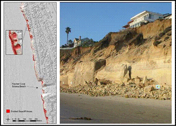
Figure 3. Examples of
how bluff erosion contributes to beach sand, as documented by Young and
Ashford, 2006. The left image shows a ~
one-kilometer stretch of bluffs in Solana Beach, with the red areas
representing sections of bluff that eroded between 1998 and 2004. The photograph shows an example of bluff
collapse in this area. This single
collapse instantly added ~890 cubic meters of material to the beach. (Reproduced by permission of Dr. Scott Ashford.)
Beach
Erosion in the Oceanside Beach Compartment
The beach compartment concept is useful because it allows us to think
of the beach system like a “bank account” for sand. Sand is added to the beach via river runoff
and bluff erosion. Sand leaves the beach
where southward longshore drift takes it into the head of La Jolla Canyon. Some sand is lost to offshore transport
during storms. Obstructions such as
jetties (the largest of which is at Oceanside Harbor—see figure 1) interrupt
the southward drift of sand, creating local pockets of accumulation on the
north sides of jetties and erosion on the south sides. The size of the beach reflects the overall
balance between gains and losses of sand.
A sand surplus (net sand
gain) produces growing beaches, while a sand
deficit (net sand loss) produces shrinking beaches.
Human activities in recent
decades have significantly reduced sand input to the Oceanside Beach
Compartment. Every major river in
Today,
coastal bluffs are suffering increased wave attack due to the combined effects
of rising sea level and shrinking beaches.
Sea level has been rising worldwide since the last glacial maximum
~18,000 years ago. During the El Niño
winters of 1982-83 and 1997-98, higher sea levels (up to 15 cm above average)
and winter storms caused significant erosion damage to bluffs. In recent decades, widespread urban
development has caused beaches to shrink, further exposing bluffs to wave
attack. Meanwhile, bluff top property
values and recreational beach use in
Property
owners along the coast have responded to the increasing threat to the bluffs
through massive armoring efforts using riprap
and seawalls.
Beach Replenishment
By the early 1990s, the
sand deficit in the Oceanside Beach Compartment had shrunk area beaches to critically
low levels. In response, the San Diego
Association of Governments (SANDAG) adopted a long-term plan for restoring the
region’s beaches. The plan embraced beach replenishment—the importation of
sand onto shrinking beaches—as the preferred strategy for beach restoration. To
justify the considerable costs, SANDAG cited maintaining quality of life,
protecting bluff top property, and continuing to attract tourism dollars to the
region (SANDAG 2007).
In 2001, SANDAG launched
the first San Diego Regional Beach Sand Project I (figure
4). Funded with $17.5 million in
federal, state and local government revenue, Project I pumped 2.1 million cubic
yards (mcy) of sand from several offshore dredge
sites onto 12 beaches from Oceanside to Imperial Beach by the Mexican
border. (For perspective, 2.1 mcy would fill one average-sized football stadium to the
brim.) Most of the sand (1.83 mcy) went to beaches in the Oceanside Beach
Compartment. Spread out evenly on the 30
miles of beaches between Oceanside and La Jolla, that amount of sand works out
to 28 inches of extra sand if you assume a 150-foot-wide beach.
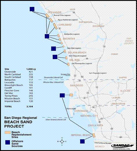
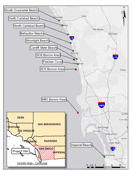
Figure
4. The 2001 Regional Beach Sand
Project I. 2.1 million cubic yards
of sand were pumped from offshore dredge sites onto 12 local beaches, with 87
percent of it (1.83 million cubic yards) going to beaches in the Oceanside
Beach Compartment. Significant widening
of replenished beaches lasted about five years on average. (SANDAG 2007.)
Measurements in the years after Project
I showed that the dredged sand lasted on beaches about five years, on
average. In other words, by 2006 most
beaches had shrunk to close to their pre-replenishment levels. In response to the return to smaller beaches
and increased risks of bluff erosion, SANDAG undertook in 2012 a second major
replenishment project: San Diego Regional Beach Sand Project II (figure
5). Project II (2012) was nearly
identical to Project I (2001), although it dredged less sand. At a cost of $28.5 million, Project II pumped
1.5 million cubic yards (mcy) of sand from offshore
dredge sites onto eight beaches from Oceanside to Imperial Beach. One key difference compared to Project I was
that surveyors of potential dredge sites for Project II made an effort to find
sand that was coarser-grained (made of bigger pieces), on the reasoning that
coarser-grained sand is harder for waves to move and will thus last longer on
the beaches.
Figure
5. The 2012 Regional Beach Sand
Project II. 1.5 million cubic yards
of sand were pumped from offshore dredge sites onto 8 local beaches. (SANDAG 2012.)
Protecting Coastal Bluffs: Science meets Politics
In California, the coastal area
from the high tide mark to the offshore zone is public property. Property can
be private down to the high tide mark, so some property owners receive permits
to build stairs or other structures down the bluff face to the public property
limit. Because individual property
owners are responsible for the costs of protecting their property, seawalls and
other bluff-stabilization constructions frequently begin and end at property
boundaries. (In other words, if you look straight up to
the top of the bluff from where a seawall begins or ends along the beach, you
will usually find that it corresponds to a property boundary at the bluff
top.)
Although
bluff-top property owners bear the cost of
bluff construction projects, such construction is regulated by state, county, and city agencies, requiring
that property owners go through a rigorous permitting process.
In 1994, the California Coastal Commission mandated that seawalls be
designed with a “naturalistic look”
for minimal visual impact (California Coastal Commission, 1994). The mandate recognizes that the beach is a
public space, and that the public’s beach-going experience is negatively
affected by non-naturalistic bluff-stabilization structures (many of which are
quite ugly). The goal of naturalistic
seawall construction is to mimic the color and texture of the natural
bluff.
The
California Coastal Commission commonly
requires an Environmental Impact Report
(EIR) before a coastal development permit can be issued. An EIR addresses the environmental
impact of a wide spectrum of alternatives, and helps agencies select the most
appropriate project for development. Some cities (with approval of the Coastal
Commission) have bypassed this time consuming and costly process and issued
“emergency permits” in special circumstances without first completing an EIR.
This practice has been, and continues to be, challenged by environmental
groups.
Sources
California Coastal Commission, 1994. Landform
Alteration Policy Guidance.
California Coastal Commission, 2008.
California Coastal Commission website, http://www.coastal.ca.gov/
Haas, J. and Driscoll, N., 2005, Sources of
Beach Sand in the Oceanside Littoral Cell.
http://coastalconference.org/h20_2005/pdf/2005/2005_10-27-Thursday/Session6ACoastal_Sediment_Master_Plan/Haas-Sources_of_Beach_Sand_in_the_Oceanside_Littoral_Cell.pdf
Kuhn, G.G., and Shepard, F.P., 1984. Sea
Cliffs, Beaches, and Coastal Valleys of San Diego County. Berkeley, University
of California Press.
Johnson, C.S., 2006, The
Making of a Natural Sandy Beach: Have Rivers in Southern California Ever Been
an Important Source of Sand? California Sea Grant Research Stories.
http://www-csgc.ucsd.edu/STORIES/NaturalSandyBeach.html
Johnsson, M. J, 2003. Establishing development
setbacks from coastal bluffs. California Coastal Commission Memorandum to
Commissioners and Interested Parties. http://www.coastal.ca.gov/W-11.5-2mm3.pdf
Patsch, K., and Griggs, G., 2006. Littoral Cells,
Sand Budgets and Beaches: Understanding California’s Shoreline. Institute of Marine Sciences, UC Santa Cruz,
and the California Dept of Boating and Waterways.
http://www.dbw.ca.gov/csmw/PDF/LittoralDrift.pdf
SANDAG (San Diego Association of
Governments), 2012. 2012 Regional Beach
Sand Project. http://www.sandag.org/index.asp?projectid=358&fuseaction=projects.detail
SANDAG (San Diego Association of
Governments), 2007. Feasibility Study: San Diego Regional Beach Sand
Replenishment Project. Prepared for the California Dept. of Boating and
Waterways, August 2007, by SANDAG and Moffat & Nichol.
http://www.sandag.org/uploads/publicationid/publicationid_1327_7318.pdf
SANDAG (San Diego Association of
Governments), 2003. San Diego Regional Beach Sand Project Fact Sheet.
http://www.sandag.cog.ca.us/uploads/publicationid/publicationid_340_1057.pdf