Beach
Dynamics
The following section
decribes beach dynamics and how
they relate to sand levels and movement in the
near-shore environment. Figure #1 is a summary of
the seasonal
changes which occur on the beaches along our
coastline. The next section
provides more specific details and explanations
with additional resources for
the subject.
Figure #1a: Winter
Conditions on the Southern
v
Highest overall coastal
erosion
v
High wave energy
v
Higher astronomical tides
(very significant)
v
Northwest swell, south
longshore current
v
Sediment/sand migrates
offshore (Lower overall sand
levels)
v
Coarser sediments ie:
smaller rocky beach
v
Upwelling, cooler,
less-clear water
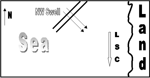
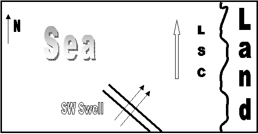
Figure #1b: Summer
Conditions on the Southern
v
Lower overall coastal
erosion
v
Lower wave energy
v
Lower astronomical tides
v
Southwest swell, slack to
north longshore current
v
Sediment/sand migrates
onto beach (higher sand levels)
v
Finer sediments ie:
larger sandy beach
v
Downwelling, warmer,
clearer water
Explanation
and Discussion
In the winter, we have
larger surf, higher
astronomical tides and lower overall sand levels. These factors combine to
create favorable conditions for coastal erosion
and are discussed in more detail below.
High sand levels in place during these
periods of high tides and surf
are critical in preventing erosion along our
coast.
Storm
Centers and Longshore Transport
The storm centers which
affect the surf in the
Seasonal
Energy Levels
The energy
levels of the waves and currents are
different in the winter vs. the
summer. This
affects the beach shape
and the amount of sand on the beach.
Stronger winter currents leave coarser
materials in the winter such as
gravel and cobbles.
Much of the
sand-sized material is transported offshore.
This results in significantly lower sand
levels on the beach. While in
contrast, the summer has smaller waves and weaker
currents and the sand
migrates back to the beach. This results in much
higher sand levels. So the
beach is narrower and rockier in the winter, and
wider and sandier in the
summer.
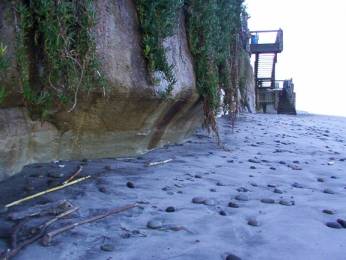
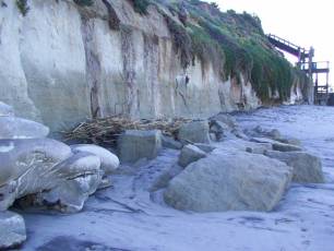
Winter beach
in Encinitas, California.
Note
gravel and cobbles on the
beach and lack
of a sandy berm.
Low sand levels in the winter
increase erosion of the
sea cliff.
Sand Levels and the Formation of
When
sand levels are low,
waves break into a sea cliff at the highest
tides. Sea caves form and
grow at the base of the cliff usually in areas
where a zone of weakness
exists. Normally these zone of weakness are
related to areas of
fracturing or faulting. The sea caves grow to the
point where they cannot
support the rocks above them and the cliff will
fail and retreat
landward. This failure type is called "rock
fall". When higher
levels of sand exist on the beach, waves will not
break into the sea cliff at
higher tides. It only takes a small increase in
the height of sand on the beach
to prevent this type of coastal erosion, usually ½
to 1 meter is sufficient.
Click here to see a great interactive Beach
Profile.
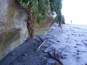
Early
stages of sea cliff
undercutting
Rock-fall due to sea
cliff failure.
and
sea cave formation due
to low
sand
levels and wave
erosion.
Tides
Tidal extremes are
greater in the winter than in the
summer in the Northern Hemisphere because of the
elliptical orbits of the earth
around the sun, and the moon around the earth. The
moon’s elliptical orbit
around the earth is on a 28 day cycle and it is
closest to the earth during the
“perigee”.
The earths orbit around the sun is on a 1 year
cycle and is closest to the sun
during the winter (farther in the summer), this is
called the ”perihelion”.
So, we get higher tidal
extremes in the winter when we
are at perigee and perihelion, because of
the increase in gravitational
force. This is very significant as only a small
increase in a high tide maximum
height can be enough to create a situation where
waves are breaking directly
into the sea cliff.
When these high
astronomical tides are combined with larger surf
generally found in the winter,
the potential for coastal erosion is maximized.